You are using an out of date browser. It may not display this or other websites correctly.
You should upgrade or use an alternative browser.
You should upgrade or use an alternative browser.
Toroid
Founding Member
The news clip said it's nearly impossible for a cat 5 hurricane to sustain itself because it will get speed wobbles. It could drop to a cat 4 before hitting Florida.
www.youtube.com/watch?v=wV_o4Rhlb0g
People stocking up and supplies are going fast.
www.youtube.com/watch?v=ua625V1Zaj0

www.youtube.com/watch?v=wV_o4Rhlb0g
People stocking up and supplies are going fast.
www.youtube.com/watch?v=ua625V1Zaj0
Caeldeth
Noble
It is not impossible for a category 5 to retain strength. It's just conditions are usually not right throughout its journey. They usually run into dry air, wind shear, high pressure and those things rip cyclones apart.
The interesting thing about this storm in particular is that there is no dry air, there is a massive abundance of tropical moisture, and very unusually warm water, and no wind shear, and there is a Bermuda high that it is avoiding all together.
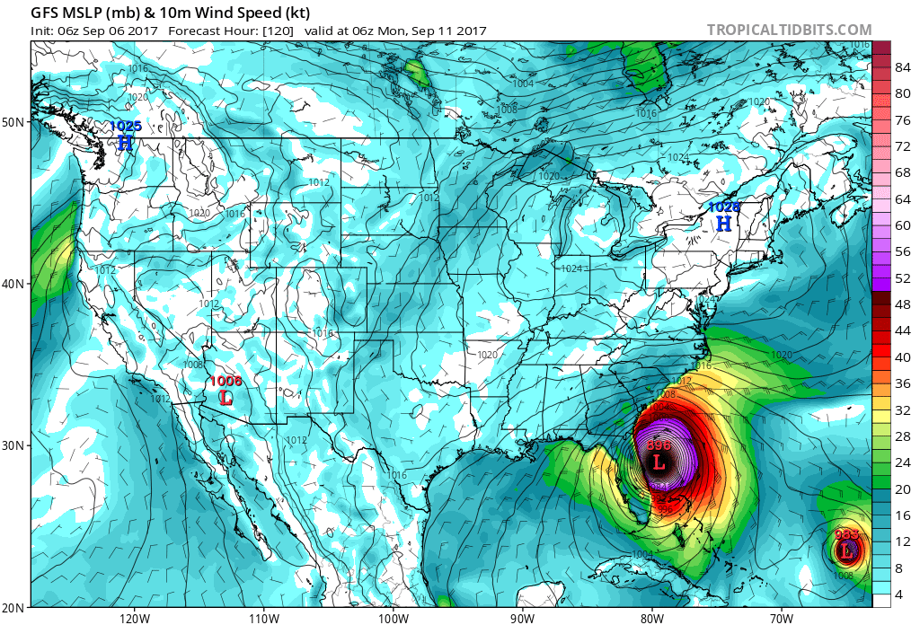
Every major weather modal right now other than the ECM which never really has a good handle on Atlantic cyclones is showing the storm continue to deepen and very rapidly deepen by 20mb or lower before landfall and making landfall as a 870 - 890mb storm. Making it one the lowest observed pressures on earth ever! This is very telling because it's what's called a trend and it's been holding for 3 days now.
I will continue to monitor this storm and give people maps that weather stations will not show, and you have to pay hundreds of dollars to view to inform the people on this forum that live around the area of this storm.
I cannot stress this enough. If you live anywhere near the path get out. Do not stay. Do not risk the lives of emergency personnel to save your sorry ass because you decided to stay.
The interesting thing about this storm in particular is that there is no dry air, there is a massive abundance of tropical moisture, and very unusually warm water, and no wind shear, and there is a Bermuda high that it is avoiding all together.
Every major weather modal right now other than the ECM which never really has a good handle on Atlantic cyclones is showing the storm continue to deepen and very rapidly deepen by 20mb or lower before landfall and making landfall as a 870 - 890mb storm. Making it one the lowest observed pressures on earth ever! This is very telling because it's what's called a trend and it's been holding for 3 days now.
I will continue to monitor this storm and give people maps that weather stations will not show, and you have to pay hundreds of dollars to view to inform the people on this forum that live around the area of this storm.
I cannot stress this enough. If you live anywhere near the path get out. Do not stay. Do not risk the lives of emergency personnel to save your sorry ass because you decided to stay.
Last edited:
Caeldeth
Noble
Geez, maybe we can get North Korea to detonate an atomic bomb there.
Then you have a radioactive hurricane. Not good.
nivek
As Above So Below
Hurricane Irma Update Statement
000
WTNT61 KNHC 060039 CCA
TCUAT1
Hurricane Irma Tropical Cyclone Update...Corrected
NWS National Hurricane Center Miami FL AL112017
815 PM AST Tue Sep 05 2017
Corrected for time in summary information
...HURRICANE WARNING ISSUED FOR GUADELOUPE...
The government of France has changed the Hurricane Watch for
Guadeloupe to a Hurricane Warning.
SUMMARY OF 815 PM AST...0015 UTC...INFORMATION
----------------------------------------------
LOCATION...17.2N 60.5W
ABOUT 85 MI...140 KM E OF ANTIGUA
ABOUT 90 MI...145 KM ESE OF BARBUDA
MAXIMUM SUSTAINED WINDS...185 MPH...295 KM/H
PRESENT MOVEMENT...W OR 280 DEGREES AT 15 MPH...24 KM/H
MINIMUM CENTRAL PRESSURE...916 MB...27.05 INCHES
_________________________
KEY MESSAGES:
1. Irma is a potentially catastrophic category 5 hurricane and will
bring life-threatening wind, storm surge, and rainfall hazards to
portions of the northeastern Leeward Islands tonight and tomorrow.
These hazards will spread into the Virgin Islands and Puerto
Rico tomorrow. Preparations should be rushed to completion before
the arrival of tropical-storm force winds tomorrow morning in Virgin
Islands and Puerto Rico.
2. A hurricane warning is in effect for the northern coast of the
Dominican Republic, with hurricane watches for Haiti, the
southeastern Bahamas and the Turks and Caicos. Irma is likely to
bring dangerous wind, storm surge, and rainfall to these areas from
Wednesday night through Friday.
3. Irma could directly affect the remainder of the Bahamas and Cuba
as an extremely dangerous major hurricane later this week. Residents
in these areas should monitor the progress of Irma and listen to
advice given by officials.
4. The chance of direct impacts from Irma beginning later this week
and this weekend from wind, storm surge, and rainfall continues to
increase in the Florida Keys and portions of the Florida Peninsula.
However, it is too soon to specify the timing and magnitude of these
impacts.
http://www.nhc.noaa.gov
nivek
As Above So Below
Hurricane Irma Update Statement
000
WTNT61 KNHC 060039 CCA
TCUAT1
Hurricane Irma Tropical Cyclone Update...Corrected
NWS National Hurricane Center Miami FL AL112017
815 PM AST Tue Sep 05 2017
Corrected for time in summary information
...HURRICANE WARNING ISSUED FOR GUADELOUPE...
The government of France has changed the Hurricane Watch for
Guadeloupe to a Hurricane Warning.
SUMMARY OF 815 PM AST...0015 UTC...INFORMATION
----------------------------------------------
LOCATION...17.2N 60.5W
ABOUT 85 MI...140 KM E OF ANTIGUA
ABOUT 90 MI...145 KM ESE OF BARBUDA
MAXIMUM SUSTAINED WINDS...185 MPH...295 KM/H
PRESENT MOVEMENT...W OR 280 DEGREES AT 15 MPH...24 KM/H
MINIMUM CENTRAL PRESSURE...916 MB...27.05 INCHES
_________________________
KEY MESSAGES:
1. Irma is a potentially catastrophic category 5 hurricane and will
bring life-threatening wind, storm surge, and rainfall hazards to
portions of the northeastern Leeward Islands tonight and tomorrow.
These hazards will spread into the Virgin Islands and Puerto
Rico tomorrow. Preparations should be rushed to completion before
the arrival of tropical-storm force winds tomorrow morning in Virgin
Islands and Puerto Rico.
2. A hurricane warning is in effect for the northern coast of the
Dominican Republic, with hurricane watches for Haiti, the
southeastern Bahamas and the Turks and Caicos. Irma is likely to
bring dangerous wind, storm surge, and rainfall to these areas from
Wednesday night through Friday.
3. Irma could directly affect the remainder of the Bahamas and Cuba
as an extremely dangerous major hurricane later this week. Residents
in these areas should monitor the progress of Irma and listen to
advice given by officials.
4. The chance of direct impacts from Irma beginning later this week
and this weekend from wind, storm surge, and rainfall continues to
increase in the Florida Keys and portions of the Florida Peninsula.
However, it is too soon to specify the timing and magnitude of these
impacts.
National Hurricane Center
iwant2believe2
Honorable
Irma is heading toward us as a CAT 5 with sustained winds of 185 mph and gusts over 200 mph. It is headed slightly Gulf side at present with a probable track straight up the middle but it matters little now. It is LARGER than the state of Florida. I'm evacuating tomorrow evening or Thursday morning at the latest. Here's some size comparisons...

iwant2believe2
Honorable
People need to understand that its the eye wall and not the eye that is the most destructive. Hurricane force winds extending 50-60 mi from eye and tropical storm force winds up to 150 mi from eye. The storm does not end when it makes landfall...it continues on its path until it weakens and dissipates which in this instance could be well into GA. East coast, West coast, inland...we're all fucked. Pardon my language but I am literally losing everything here. I have heard so many people today just totally ignore the facts and reality. Its maddening. They think it will hit Miami and send a few showers their way. These are the people who will be on their rooftops waving frantically for rescue.
Caeldeth
Noble
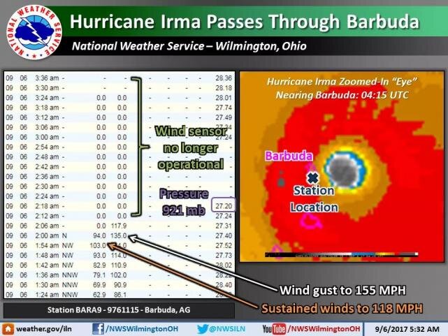
Its gone over Barbuda island.. some 2000 residents living there. Cant find any reports of what happened.
Are they still there ?
That area isn't doing very good.
Attachments
Caeldeth
Noble
Its gone over Barbuda island.. some 2000 residents living there. Cant find any reports of what happened.
Are they still there ?
Here you go.