Hurricane Dorian

Toroid

Founding Member
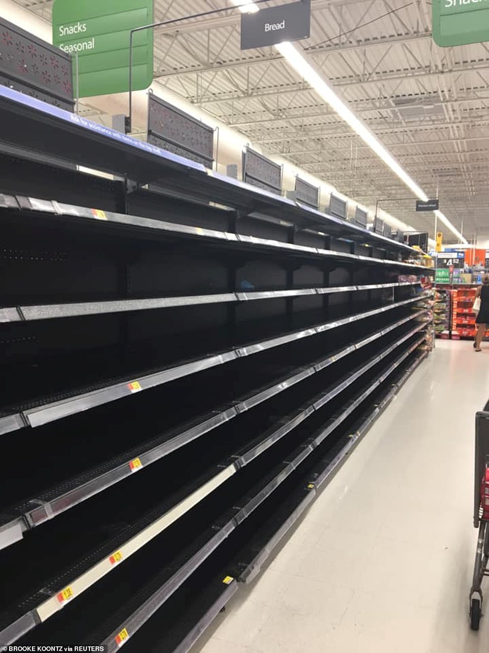
People in Florida are clearing store shelves to prepare for Hurricane Dorian. It could increase to a Cat 4.
Hurricane Dorian spares Puerto Rico but is expected to strengthen before hitting Florida | Daily Mail Online
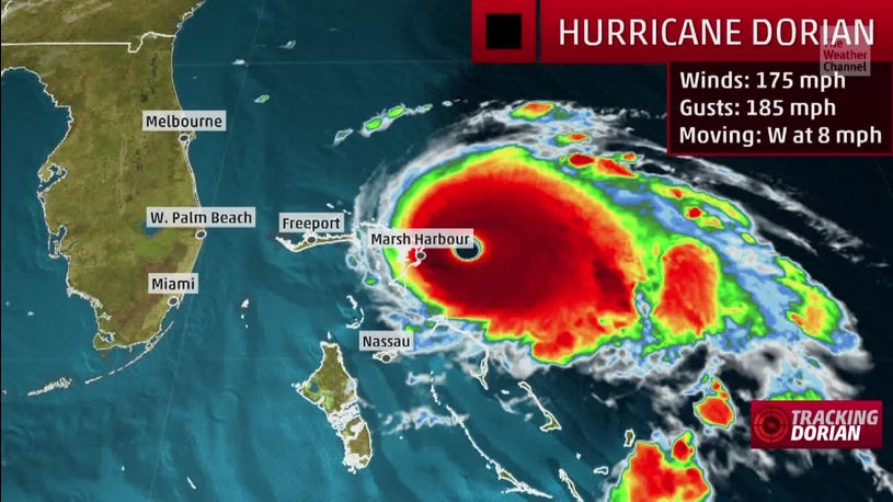
Incredible footage from the International Space Station shows Hurricane Dorian swirling in the Atlantic
  • The footage shows Dorian strengthening at 1.05pm EDT on Thursday north of Puerto Rico
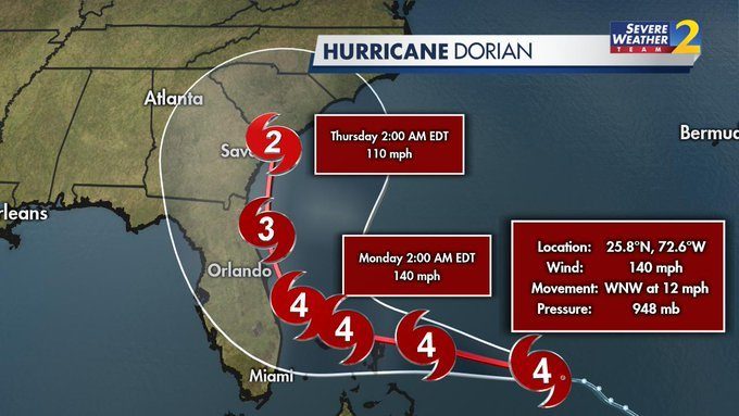
  • Hurricane Dorian, a Category 1 storm, is set to escalate into a Category 4 as it crosses warm Atlantic waters
  • The hurricane is expected to make landfall on Florida's eastern coast by Labor Day Monday
  • As of 11am EDT Thursday, Dorian is in open waters blowing at 85mph, 220 miles northwest of San Juan
  • Hurricane Dorian made landfall on the Virgin Islands Wednesday at 2pm EDT, causing power outages
  • The National Hurricane Center predicts Dorian could hit Florida as soon as late Sunday or early Monday
  • Gov Ron DeSantis declared a state of emergency and urged residents to prepare for a Labor Day strike
  • Dorian caused some flooding and damage across the Caribbean earlier this week
  • It was expected to hit Puerto Rico on Wednesday but passed to the east of the territory, leaving it unscathed
  • Donald Trump shared a warning to Floridians Thursday morning saying: 'It will be a very big Hurricane'
  • Thursday afternoon he cancelled his trip to Poland in light of the hurricane
  • Florida is not currently under any watches or warnings and no evacuations have been ordered yet
082919+dorian+track+5am.gif

17839442-7405353-image-a-47_1567094365203.jpg
 

nivek

As Above So Below

Toroid

Founding Member
"I Feel Helpless": Bottled Water, Gas Shortages Reported As Floridians Brace For Hurricane Dorian
Published on Aug 29, 2019
By now, this has become a familiar scene for millions of Americans, particularly those living in the southeastern states of Florida, Georgia and the Carolinas, as well as Texas and Louisiana, all of which have been rocked by major hurricanes in recent years. With Hurricane Dorian barreling toward Florida, expected to make landfall as a powerful Category 4 hurricane, with 130 mph winds, this weekend.

According to WSJ, Floridians could begin feeling the impact of the storm as soon as Saturday. The NHC said Thursday that the storm is a Category 1 hurricane with sustained winds of 85 mph, moving northwest over the Atlantic Ocean. Though it's too early to say exactly where it will make landfall, projections suggest it will hit the northwestern Bahamas before moving on to central and southern Florida.

www.youtube.com/watch?v=PN1vW3xJNaQ
 

nivek

As Above So Below
Its now a category 3 storm...

Hurricane Dorian has ALREADY strengthened to a Category 3: Monster storm set to hit Florida on Labor Day keeps growing as it barrels towards the state - and forecasters warn there's nothing stopping it becoming a CATEGORY 5

Untitled.png

Some forecasters say there is a chance the storm will become the highest classification on the scale because Dorian has now developed an eye. 'Hurricane #Dorian has developed an eye...Expecting it to become a major hurricane today,' said meteorologist Ryan Maue on Twitter on Friday. 'Nothing currently stopping storm from reaching Category 5. There I said it.' On Friday afternoon, the storm became a Category 3 hurricane. By the time Dorian hits Florida, it is likely to hit as Category 4 or Category 5 storm. If it becomes a Category 5, Floridians will have to battle wind speeds of more than 156mph.

.
 

Toroid

Founding Member
It's now a Cat4.
7.5m Florida residents could be without power as Hurricane Dorian is expected to hit as a Category 4 | Daily Mail Online
A new model predicts that 7.5 million Florida residents will lose power as a result of Hurricane Dorian
  • The storm's maximum sustained winds increased on Friday morning to near 110mph near the Bahamas
  • Dorian became an extremely dangerous Category 4 storm on Friday night and is gaining momentum
  • The Trump administration said it is preparing for Dorian's arrival by shipping supplies to affected areas
  • Meteorologists say the storm could be comparable to Hurricane Andrew, which devastated Florida in 1992
  • Governor Ron DeSantis declared a state of emergency for all of Florida's 67 counties on Thursday
  • Some meteorologists warned that Dorian could hit as a Category 5 because it has developed an eye

www.youtube.com/watch?v=bmU8DQ1lwOY
 

nivek

As Above So Below
This has turned into a dangerous storm and it continues to gain strength...I'm preparing this weekend for the possibility of usually high winds and flooding that may come next week even though I'm a few hundred miles inland...

Hurricane Dorian tracks slightly north, with winds of 140 mph

Hurricane Dorian lifted slightly north Friday night, according to the National Hurricane Center’s latest forecast track at 11 p.m.

While that appears to be better news for South Florida, most of the state remains in the cone of uncertainty.

The Category 4 storm could be near the east coast of Florida late Monday. Its current maximum sustained winds are 140 mph. Some additional strengthening is possible tonight and Saturday.

The forecast track is still heading generally northwest, with Dorian 545 miles east of West Palm Beach. But first, it is expected to make a devastating impact on the northern Bahamas.

(more on the link)

s113487357.jpg
 

Shadowprophet

Truthiness
This has turned into a dangerous storm and it continues to gain strength...I'm preparing this weekend for the possibility of usually high winds and flooding that may come next week even though I'm a few hundred miles inland...

Hurricane Dorian tracks slightly north, with winds of 140 mph

Hurricane Dorian lifted slightly north Friday night, according to the National Hurricane Center’s latest forecast track at 11 p.m.

While that appears to be better news for South Florida, most of the state remains in the cone of uncertainty.

The Category 4 storm could be near the east coast of Florida late Monday. Its current maximum sustained winds are 140 mph. Some additional strengthening is possible tonight and Saturday.

The forecast track is still heading generally northwest, with Dorian 545 miles east of West Palm Beach. But first, it is expected to make a devastating impact on the northern Bahamas.

(more on the link)

View attachment 7775
Poor Florida, I was talking to Tates Dad today, He swears that when he was younger Hurricanes were just less frequent than they are today, I sometimes wonder, If it's possible that someone has weaponized the weather.
 
Poor Florida, I was talking to Tates Dad today, He swears that when he was younger Hurricanes were just less frequent than they are today, I sometimes wonder, If it's possible that someone has weaponized the weather.
It's global warming. The oceans act like a heat sink, so most of the global warming is happening in the oceans. Warmer oceans yield more and stronger hurricanes. And also result in the melting of the polar ice caps (especially the Arctic), which is also happening irrefutably.
 
Last edited:

nivek

As Above So Below
Yep, if it follows this path and goes straight up norht through central North Carolina then it will head right to me lol...

Hurricane%20Dorian%20track%20as%20of%205%20a.m.%20Saturday_1567246442026.jpg_16242437_ver1.0_1280_720.jpg
 

Wade

Stare..... They are always staring
This seems kind of familiar, it's as if I dreamt about it or we've been through this or something. Oh well there's always a nuke as a last resort:eek:
 

nivek

As Above So Below
I went into town yesterday and got some supplies, and yesterday afternoon I ran a ground cable from my workshop to my house so I can feed power from my solar batteries to the house if we lost the grid power...Also had to postpone the installation of my Faraday cage, was due to begin work Tuesday but this storm coming has delayed that project now...

....
 

Wade

Stare..... They are always staring
A man with a plan, good thinking. Me, I would probably wait for someone to rescue me.

I'm pretty sad when you stop to think about it :blush8:
Not terribly surprising it's at level 5, I wonder what the two high pressure systems floating around near it are bringing to the table?
 
Last edited:

nivek

As Above So Below
A man with a plan, good thinking. Me, I would probably wait for someone to rescue me.

I'm pretty sad when you stop to think about it :blush8:
Not terribly surprising it's at level 5, I wonder what the two high pressure systems floating around near it are bringing to the table?

Fortunately I'm far enough inland that I won't get the full force of that storm, but I'll probably get very high winds and days of rain which has taken out our grid power before...I can currently go about 4 days on battery power before I need sunlight again to charge the batteries, next year I hope to have a wind generator to back up the solar lol...

Yeah this storm keeps getting stronger and stronger, almost 175 mph winds now, geez, I hope the coastal land can weaken it and slow it down some, people on the coast just need to leave for inland safety at this point...


nivek

As Above So Below
This is a powerful storm...

1567347135343_0901_Dorian_Update_175_MPH.jpg
 

Wade

Stare..... They are always staring
Yep, I just got a notice about that 175 mph!!
Hopefully it stays off shore on its journey up the coast. That would be a pretty bad storm surge with the seasonal high tides also taking place.
 

Wade

Stare..... They are always staring
Maximum sustained winds have increased to 180 mph, putting Dorian in a tie for the third-highest sustained wind speed among all Atlantic hurricanes. It's also the strongest hurricane in modern records for the northwest Bahamas.

*Show Off*
 

nivek

As Above So Below
This one is the second strongest storm by wind speed...

EDZTutvXkAEuMMD.jpeg
 
Top