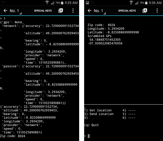
UFO tracking system

Filakius

Adept
OK.
When I went through this head space, here are some of the problems identified before I started.
  • Different types of Devices...
  • Android
  • Apple Crap
  • Windows Crap
  • Screen resizing if using an App
  • (this can be a diabolical nightmare even under one platform such as Android
  • In that one phone has a wider screen than another, more pixels etc)
  • Programming Platforms and plugins needed for each
  • Distribution to Apple Store
  • Distribution to Google Apps Store
  • Distribution to Windows freeware places
  • Superseded packages.
  • People swapping devices every year, will they always reinstall.
  • Maintaining security on the app,
  • Patching
  • The List goes on....

This is why I went for a web server based approach. Almost all of these issues go away or at least lessen dramatically if you are running a web based app,maintained on a central server. HTML etc changes I agree, but there is usually backward compatibility built into each new iteration of HTML, PHP, CSS etc
It is usually just new features added.
Hey, now we're getting somewhere.
Python is native with Linux, runs on Windows. handles C++, HTML, CSS, CSV, JSON etc, and uses SL4a for Android and Kivy for iOS devices.

I'm just reading up on version compatibility and figuring out which is best...
Dashboards | Android Developers
Marshmallow is the obvious winner, but maybe Version 4.1 could still be compatible with newer phones if we keep it basic. I'll ask around before committing, and keep working on the core code.

The other thing for me was, I never expected to get any help writing it, so I stuck with what I knew. And recognized what I didn't. I am not a big social media fan, nor am I a fan of anything apple. So I have never coded for an apple device.
Yea same. I don't want to learn it.
I guess that is why Apple apps costs money, while the exacts same apps are free on Android.
Python is capable of writing iOS app though, just need to learn it's API commands I guess.

For me approaching it on my own the web based approach was a no brainer, So long as you had a half decent web page design that was well coded. You covered all platforms, All devices, all OS's in one fell swoop.
No updates to distribute, security and backups etc all maintained by the provider.
Yea, I think it's a great idea. I know basic HTML and want to start learning Javascript.

I have a friend who "pen-tests" websites regularly and its scary what he can do. I personally could not guarantee everyone's safety.., and would need money to pay someone to ensure the site was consistently secure.
Most likely buy a pre-made site similar to this forum.

I can probably handle all the mobile platform stuff if you want to start the page.
I can write scripts that will work with your program and website.
 

Filakius

Adept
The other thing I thought of is less tangible and far harder to quantify. But it is something I considered.
In the early days of sound cards, there was a few options, Creative, Gravis Ultrasound, I cant remember now, but there were others. Creative made available to all what was needed to code for it, build hardware for it, incorporate it on motherboards. Now what is pretty much the base chipset on most motherboards? Creative. Had you even heard of Gravis Ultrasound? they are long dead, or might as well be, because they tried to keep there code close.
Haha, yea Soundblaster [AWE 32]. Setting up IRQ channels and junk...
Linux is open source.., I think Apple is based off Linux (Unix) but with their own Kernel and dependencies that are not open-source. But as with Windows, they make money by keeping their algorithms secret that allow games to be played, and 4k videos to be edited. I think anyway....

Free and open-source is the way to go.
I worry someone will just take my code.., and spend time working on a better GUI or ease-ability and slap $1 on it.
I read market R&D which suggested people think paid apps are more professional and trustworthy.
I guess if you saw my app next to a more professional looking one for $1, some would assume its the better one generally.

Oh speaking of Steam.., they have their own OS now. I wanna try this.
SteamOS
 
Last edited:

nivek

As Above So Below
Oh speaking of Steam.., they have their own OS now. I wanna try this.
SteamOS

Yes on the outside, it's really another flavour of Linux though, but I like Linux, I use 3 different flavours currently lol...
 

Dundee

Fading day by day.
Hey Mate,
I have to say, as cool as this project sounds, I have a bunch of unfinished programs that could be cool.
Upon reflection, I am happy to help if I can, but in my opinion, going down the track of an app is not the way. Too many pitfalls, too many problems. I think I will stick with my approach. Hopefuly I will get some inspiration to get over the xml to SQL hurdle and do it via a web-page. IMHO that is the best solution. No...the simplest solution.
 
Last edited:

Filakius

Adept
I am happy to help if I can, but in my opinion, going down the track of an app is not the way. Too many pitfalls, too many problems.
That's fair enough. Let me know if I can help.

I think I will stick with my approach. Hopefuly I will get some inspiration to get over the xml to SQL hurdle and do it via a web-page. IMHO that is the best solution. No...the simplest solution
I like the idea.
 

nivek

As Above So Below
Haha nice, what did you end up picking?

What do you mean?...The three I use are not trial runs, I use them all the time, Linux SMS server that runs one of my servers, Salix Linux on my laptop and Slackware Linux on a desktop PC....
 

Filakius

Adept
What do you mean?...The three I use are not trial runs, I use them all the time, Linux SMS server that runs one of my servers, Salix Linux on my laptop and Slackware Linux on a desktop PC....
Sorry, I meant which 3 did you pick. I just worded it wrong. Its been a long day.
The SMS server sounds cool. I went Jesse for Raspberry Pi, Mint for building my own OS, Parrot's my main.
 

nivek

As Above So Below
Sorry, I meant which 3 did you pick. I just worded it wrong. Its been a long day.
The SMS server sounds cool. I went Jesse, Mint, Parrot.

Actually a fourth Linux I use too, if you count Android Nougat on my tablet lol...
 

Filakius

Adept
Hey Mate,
I have to say, as cool as this project sounds, I have a bunch of unfinished programs that could be cool.
Upon reflection, I am happy to help if I can, but in my opinion, going down the track of an app is not the way. Too many pitfalls, too many problems. I think I will stick with my approach. Hopefuly I will get some inspiration to get over the xml to SQL hurdle and do it via a web-page. IMHO that is the best solution. No...the simplest solution.
So people upload GPS co-ords to the website.., and the website handles the notification on a map.

Do you send email notifications to other members?
I stopped on the mobile, and started making a program to handle emails and stuff...
UFO-Tracking-and-monitoring/PC APP.py at master · UFOAPPS/UFO-Tracking-and-monitoring · GitHub

I got that phone app mostly working.
It turns GPS on for 5 seconds, and gets data.
Users can just send their current ZIP code.., instead of actual co-ordinates.

I also sorted out a GPS option.
Before co-ordinates leave your phone.., the longitude & latitude are muddled up by 1 - 2kms (or whatever) using a random number and adding/subtracting to it.

The safer co-ordinates are then sent via email, IM or any other vessel. Your real ones never leave your phone and delete immediately.

So instead of 33° 51' 54.5148'' S and 151° 12' 35.6400'' E
The number sent is 35° 52' 64.5449'' S and 152° 11' 25.5460'' E

I tested it, and its usually around 1km - 2km difference.
But I am open to leaving that out of the App completely.
 
Last edited:

Dundee

Fading day by day.
So people upload GPS co-ords to the website.., and the website handles the notification on a map.
Google Maps uses a text file that is pretty much in XMLish format, it is pretty cumbersome but it ia what it is. So to add a point, you add block of xmlish code to the text file. maybes 6 or 8 lines minimum, if your point has no mouse over text of comments. So in the example I shown you I have manually created those points in the text file.
The web page then has a few lines of code that uses the API key I got from the google maps people, reads the points from the xml file then plots the points on the map.

No here lieth my problem. I want people to be able to simply go to my page, scroll google maps to where they saw there UFO, Click on the map and add a point with a short string describing the sighting, direction of travel, etc.
This in itself is reasonably achievable, I have found code that will sort of do that. But, for practical reasons I want every point to be stored in an SQL file in a database structure. It needs to be this way as there is lots of other stuff that needs to be recorded such as region (for emailing) direction of travel anticipating the next region, again for emailing. Time of sighting, description, Otionally who saw it, and probably a lot of other stuff when I get that far.
So I need to write server side code that each time a visitor uploads a sighting, it ipoint to weed out spammers) then creates server side xml on the fly. See storing it as SQL, has a heap of advantages, searching for points, particular sightings, particular times and types. Like search for all sightings in southern California between July 2017 and December 2017. See where i am going with it.

Do you send email notifications to other members?
Well I hadn't got that far but yes, I was going to break up the planet into chunks or regions.
When you add your email (also to be stored in SQL) to the notification list, you would have an option to subscribe to regions of interest. So if I add a point in your region, the server would look through the SQL subscriber list and generate an email to all people who subscribe to that region.
It would be super short and simple and all relevant info in the subject heading. Perhaps something like.
"Msg from UFO Track. UFO Sighted in your area"
That way people don't actually have to open the email. Reducing the risk of hackers doing the virus dance.
The user then just clicks on his bookmark on his phone, PC, tablet or whatever. Thr page loads, they log in and it maps to there preferred location by default. Click on a button that says show new points, you get a list in a list box and click to see them.

I stopped on the mobile, and started making a program to handle emails and stuff...
UFO-Tracking-and-monitoring/PC APP.py at master · UFOAPPS/UFO-Tracking-and-monitoring · GitHub

I got that phone app mostly working.
It turns GPS on for 5 seconds, and gets data.
Users can just send their current ZIP code.., instead of actual co-ordinates.

I also sorted out a GPS option.
Before co-ordinates leave your phone.., the longitude & latitude are muddled up by 1 - 2kms (or whatever) using a random number and adding/subtracting to it.

The safer co-ordinates are then sent via email, IM or any other vessel. Your real ones never leave your phone and delete immediately.

So instead of 33° 51' 54.5148'' S and 151° 12' 35.6400'' E
The number sent is 35° 52' 64.5449'' S and 152° 11' 25.5460'' E

I tested it, and its usually around 1km - 2km difference.
But I am open to leaving that out of the App completely.
Well done,, so how have you gotten past the problem of storing past sightings. Does your app, send the new sighting via text or something to all the other users of the app. How do I know here in Australia on my app, that you have just seen a ufo. If it is via email of text, and you have 200 users, thats 200 texts or emails your app needs to send when you add a sighting? How have you solved that. I use a corporate phone in my job and while I get an amount of private use, I would be questioned for sure on that kind of traffic.
 

Filakius

Adept
Well done,, so how have you gotten past the problem of storing past sightings. Does your app, send the new sighting via text or something to all the other users of the app. How do I know here in Australia on my app, that you have just seen a ufo. If it is via email of text, and you have 200 users, thats 200 texts or emails your app needs to send when you add a sighting? How have you solved that. I use a corporate phone in my job and while I get an amount of private use, I would be questioned for sure on that kind of traffic.
I am not a fan of looking at UFO reports from the past (I.e. more than 24 hours ago)
I feel as though we have exhausted this avenue for the past 70+ years, and seems to be a dead end.

I wanted a super fast notification system.
This is what I have working so far;

MOBILE PHONE APP (GitHub - UFOAPPS/Mobile-App)
-See UFO
-Unlock phone
-Open App
-Select option (Send GPS, Send ZIP code, Send no current location if "zone" already selected upon registration)
-Program sends email to UFO centre

PC PROGRAM (GitHub - UFOAPPS/PC-Control-Centre: Checks BOT email account. Sends notifications to other members)
-Checks UFO centre's emails (filters non-members + spam)
-IF member sent location... Copy email body (current GPS location or ZIP code)
-IF user did NOT send location.., look-up members "preset zone" (email/username = preset location)
-Search for nearby users on notification list. (E.g. within X distance of 33° 51' 54.5148'' S and 151° 12' 35.6400'' E, or if ZIP code matches.
-Send email alert to all nearby members.

Working on allowing members to choose how they are notified. I would prefer a Viber message or Messenger because I rarely check emails.., and don't want to set up email notifications because I get heaps everyday, and would not be able to distinguish a UFO alert from others.
 

Dundee

Fading day by day.
I am not a fan of looking at UFO reports from the past (I.e. more than 24 hours ago)
I feel as though we have exhausted this avenue for the past 70+ years, and seems to be a dead end.

I wanted a super fast notification system.
This is what I have working so far;

MOBILE PHONE APP (GitHub - UFOAPPS/Mobile-App)
-See UFO
-Unlock phone
-Open App
-Select option (Send GPS, Send ZIP code, Send no current location if "zone" already selected upon registration)
-Program sends email to UFO centre

PC PROGRAM (GitHub - UFOAPPS/PC-Control-Centre: Checks BOT email account. Sends notifications to other members)
-Checks UFO centre's emails (filters non-members + spam)
-IF member sent location... Copy email body (current GPS location or ZIP code)
-IF user did NOT send location.., look-up members "preset zone" (email/username = preset location)
-Search for nearby users on notification list. (E.g. within X distance of 33° 51' 54.5148'' S and 151° 12' 35.6400'' E, or if ZIP code matches.
-Send email alert to all nearby members.

Working on allowing members to choose how they are notified. I would prefer a Viber message or Messenger because I rarely check emails.., and don't want to set up email notifications because I get heaps everyday, and would not be able to distinguish a UFO alert from others.
Cool, sounds like you have it sorted. I don't use viber or Facebook messenger or the likes, but will be good for the younger ones. But for my part I am a big privacy advocate. So I am not a big fan of the concept of letting users know I am near, like certain dating apps. As a parent it spooks me a little. And as for older records, for me that was a major influence. As well as getting the up to date notifications in real time, you can see trends over years and times of day and so on. Lots of advantages with that. For example every Tuesday night about 1:00 am persons see a UFO in a certain area. Oh what a coincidence, that is when the Plane to Bali leaves the Airport. Scrub that report.
Looks like we have different directions in mind. Be interested to see how your app turns out :)
Cheers
 

Filakius

Adept
I turn the GPS data in a dictionary. Lists within lists, can serach etc.
Search for a keyword "LONGITUDE" and "LATITUDE" and "ZIP"
Real co-ordinates never leave your phone.

long = location.get('longitude', 0)
latt = location.get('latitude', 0)
r = random.randint(1, 2)
print('Scrambled GPS')
print(long + r)
print(latt + r)


Slightly modify the longitude and latitude (if user wants to send location)
Currently changes it about (+/-) 1km - 2km. Will add option to change scale from 1km difference to 5km difference if needed.

(I don't think I got GPS signal in this screenshot, so it back-up tried tower triangulation. -Line 2: 'GPS': None)
lADDcaq.png

(These are not real co-ordinates. Example only)

I'll take some screen shots of email being sent. (Option 2 on the app screen)
Then screen shots of the PC program that handles emails and more. Just a bit buggy atm.

All code is open-source located here Mobile-App/IM-GPS.py at master · UFOAPPS/Mobile-App · GitHub
 
Last edited:

Dundee

Fading day by day.
I turn the GPS data in a dictionary. Lists within lists, can serach etc.
Search for a keyword "LONGITUDE" and "LATITUDE" and "ZIP"
Real co-ordinates never leave your phone.

long = location.get('longitude', 0)
latt = location.get('latitude', 0)
r = random.randint(1, 2)
print('Scrambled GPS')
print(long + r)
print(latt + r)


Slightly modify the longitude and latitude (if user wants to send location)
Currently changes it about (+/-) 1km - 2km. Will add option to change scale from 1km difference to 5km difference if needed.

(I don't think I got GPS signal in this screenshot, so it back-up tried tower triangulation. -Line 2: 'GPS': None)
lADDcaq.png

(These are not real co-ordinates. Example only)

I'll take some screen shots of email being sent. (Option 2 on the app screen)
Then screen shots of the PC program that handles emails and more. Just a bit buggy atm.

All code is open-source located here Mobile-App/IM-GPS.py at master · UFOAPPS/Mobile-App · GitHub
Nice Keep up the good work.
 

Filakius

Adept
Nice Keep up the good work.
I'm just getting into HTML4 now. I was relying on SMTP to send notifications from the phone.., as that seems to be the easiest / secure. But I might just set up a server like you were saying earlier.

What are you up to these days? Would you like to work on it together? I have done a bit to add to your idea of creating a map of all sightings, but not HTML. I have half a program that can get GPS co-ords and then I am working on adding them to the map. making my own GPS reference points on the map, and adding the data to that area.
 

Dundee

Fading day by day.
I'm just getting into HTML4 now. I was relying on SMTP to send notifications from the phone.., as that seems to be the easiest / secure. But I might just set up a server like you were saying earlier.

What are you up to these days? Would you like to work on it together? I have done a bit to add to your idea of creating a map of all sightings, but not HTML. I have half a program that can get GPS co-ords and then I am working on adding them to the map. making my own GPS reference points on the map, and adding the data to that area.
Cool, sounds like you have been busy. :)
 
Top